
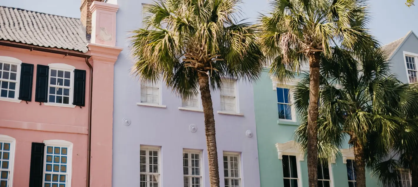
From 13 pastel row houses in Charleston to a ghostly boneyard beach on Edisto Island to the East Coast’s most recognizable lighthouse, these are the Carolina coast spots your camera has been waiting for.
The Carolina coast doesn’t need a filter. Thirteen pastel row houses painted on a Colonial-era street in Charleston. A half-mile of bleached skeletal trees standing in the Atlantic surf on a deserted Lowcountry island. A black-and-white spiral lighthouse so tall it casts a shadow 300 yards long. This coastline was putting pictures on walls long before anyone invented the concept of going viral. It hasn’t slowed down since.
What follows is a guide to the most photographed, most shared, and most visually extraordinary spots across both states, from the Outer Banks to the Lowcountry. Some are famous. Some are dramatically underrated. All of them reward the photographer who shows up at the right hour with a little local knowledge in their back pocket. That’s exactly what this guide provides.
The South Carolina Icons
Rainbow Row: East Bay Street, Charleston
Most photographed row of homes in America · 79–107 East Bay Street
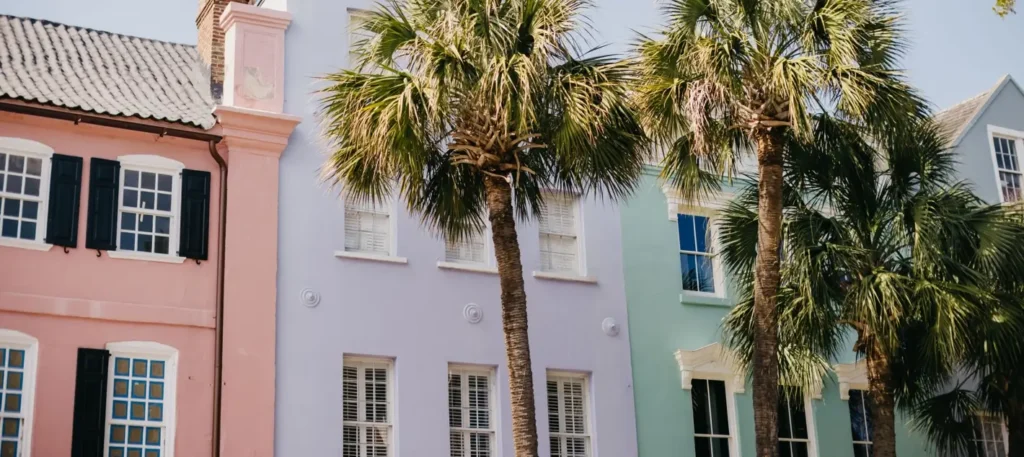
Thirteen Georgian row houses in thirteen shades of pastel, rose, lemon, mint, peach, and variations in between, stretching along East Bay Street in Charleston. These houses were built around 1740 as merchant storefronts with owner-occupied living quarters upstairs. After the Civil War, they fell into disrepair and became a slum. Dorothy Porcher Legge changed that in 1931 when she purchased properties at 99–101 East Bay and painted them pastel pink, inspired by a colonial Caribbean color palette. Neighboring homeowners followed. By the late 1940s, restoration was largely complete. City ordinances now mandate that those colors stay, which is exactly why they still look this way.
Today, Rainbow Row is the most photographed row of homes in America. Arguably one of the most photographed streets on the entire East Coast. The Atlas Obscura entry calls it “reportedly the most photographed spot in the whole city.” All 13 homes are private residences; no public entry, no tours inside the gates. The exterior, however, is entirely free and entirely worth a 6 AM alarm.
Best light: 11 AM–1 PM May–July (sun directly illuminates facades)
Or: Early morning golden hour, before crowds
Parking: East Bay/Prioleau Garage nearby State: SC
Local’s Take:
What most visitors do wrong: they show up at noon in August when the sidewalk is wall-to-wall tourists and the light is flat. The real move is arriving at 6–7 AM in spring or early summer. You’ll have the entire street to yourself, and the mid-morning sun angle, when it hits those facades directly, produces the kind of saturation that makes people ask “did you edit that?” You didn’t. That’s just Charleston.
Boneyard Beach at Botany Bay Plantation: Edisto Island
4,600-acre heritage preserve · Lowcountry’s most haunting shoreline
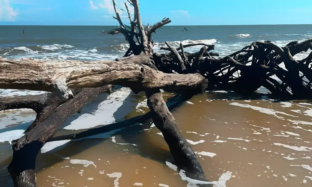
About 45 miles south of Charleston, off SC Highway 174, something extraordinary is happening at the edge of the Atlantic. The ocean is eating the land slowly, relentlessly, and as it does, it’s exposing the root systems and trunks of the maritime forest that once stood inland. The result is Boneyard Beach on Edisto Island: three miles of white sand studded with ghost trees, sun-bleached and salt-weathered, standing half-in and half-out of the surf. Some lean. Some have fallen. All of them are extraordinarily photogenic.
Botany Bay Plantation itself covers 4,600 acres, including pine hardwood forests, freshwater ponds, historical plantation ruins (the site was once two Colonial-era Sea Island cotton plantations), and a half-mile walk through marsh and maritime forest before you reach the beach. The SC Department of Natural Resources has managed it as a wildlife preserve since it was donated to the state in 1977. It opened to the public in 2008 and immediately became one of the most sought-after photography destinations in the Southeast. Loggerhead sea turtles nest here in season. Painted buntings flit through the forest. And on the beach, shells pile up in tidal pools because shell collection is strictly prohibited, which means the beach stays extraordinary.
Best timing: Low tide only, beach impassable near high tide
Best light: Sunrise (dramatic; fog common in spring)
Closed: Tuesdays and scheduled hunt days
Walk in: ~0.5 miles to beach from parking area State: SC
Pro Tip:
Check the SC DNR website for the Botany Bay closure calendar before you go. Tuesdays are always closed. Controlled hunt days close the preserve seasonally in fall and winter. Arriving at the wrong time means a locked gate — and a 90-minute drive from Charleston for nothing.
“The ocean is taking the land inch by inch. The boneyard is the evidence, and the evidence is beautiful.”
Cherry Grove Pier on North Myrtle Beach
Grand Strand sunrise gold · The pier that faces east at first light
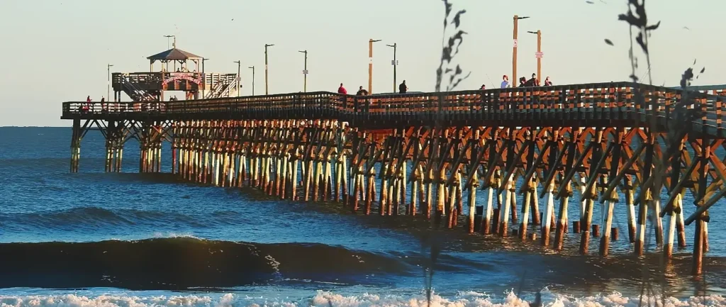
North Myrtle Beach’s Cherry Grove section sits at the northern end of the Grand Strand, and the pier that extends into the Atlantic here provides one of the most photogenic sunrise compositions on the entire Carolina coast. The wooden planks function as a leading line straight into the horizon. Low morning light bounces off the wet sand on either side, creating mirror-like reflections beneath and alongside the structure. At the right moment, roughly 20 minutes after sunrise on a calm summer morning, the whole scene turns gold.
Cherry Grove is also significantly less crowded than the main Myrtle Beach strip, which matters enormously for photography. Fewer umbrellas, wider beach, quieter atmosphere. The pier itself sits within a campground, which means a nominal $5 fee for pier access, but the surrounding beach is fully public. Additionally, Cherry Grove Point, a short walk out to the northernmost tip, is considered by local photographers among the most dramatic sunset locations on the entire Grand Strand, surrounded by water on three sides with natural dune framing.
Best timing: 20–40 minutes after sunrise
Angle: Under and alongside pier for reflection shots
Pier access: ~$5 fee (campground) State: SC
Charleston’s Historic Battery & Waterfront Park
Pineapple Fountain · Harbor views · Antebellum mansions
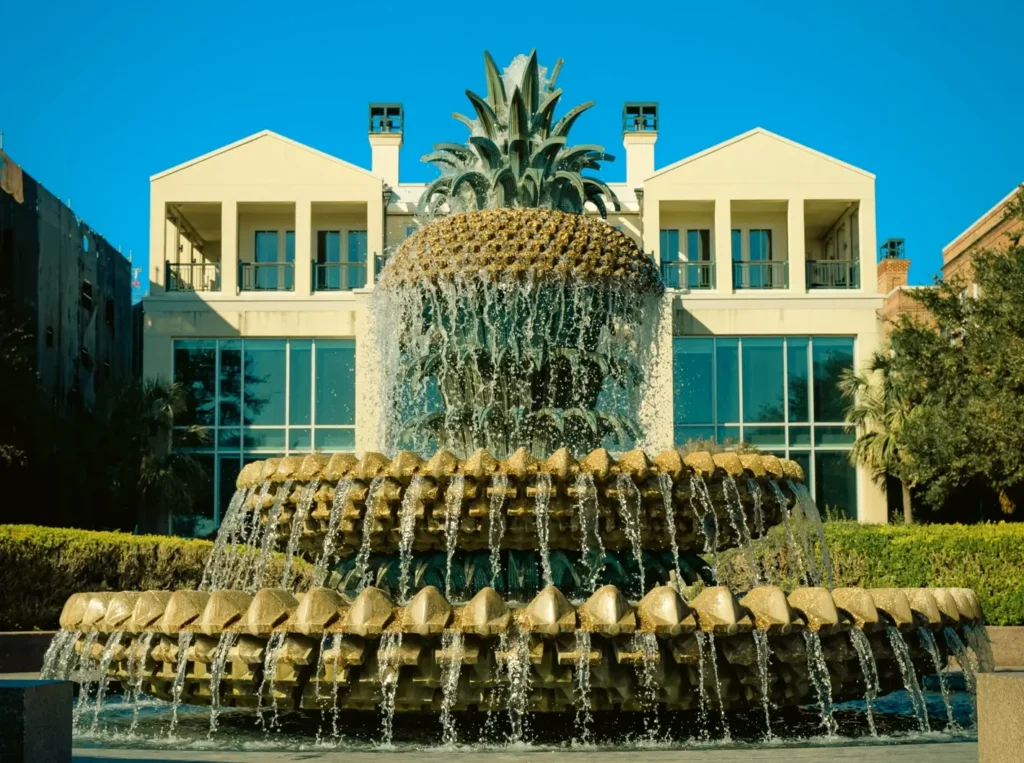
The Battery promenade runs along the southern tip of the Charleston peninsula where the Ashley and Cooper Rivers meet the harbor, with Fort Sumter visible across the water and a row of antebellum mansions lining the landward side. It’s one of the most structurally layered photography compositions in South Carolina, harbor, historic seawall, century-old live oaks, and mansion porches all in a single frame. Waterfront Park, just north of it, adds the iconic Pineapple Fountain, which has become one of Charleston’s most recognizable Instagram subjects in its own right. Pineapples have symbolized Charleston hospitality for centuries; the fountain delivers that symbolism in a photogenic package.
Best timing: Golden hour; early morning before tour traffic
Fountain location: Waterfront Park, end of Vendue Range State: SC
Murrells Inlet & Brookgreen Gardens
Lowcountry marsh gold · Spanish moss · America’s largest outdoor sculpture garden
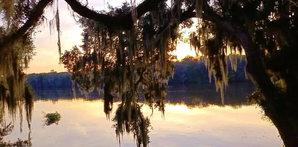
Murrells Inlet is the “Seafood Capital of South Carolina.” Still, for photographers, it’s something else entirely: a tidal creek village where the boats, docks, marsh grasses, and live oaks draped in Spanish moss combine to create quintessential Lowcountry compositions. Adjacent to Brookgreen Gardens is recognized as the largest outdoor sculpture garden in North America, and its allées of centuries-old live oaks create one of the most photographed canopy tunnels on the Carolina coast. Travel + Leisure named it one of America’s most beautiful gardens. The wetlands and wildlife sanctuary on the Brookgreen property add great blue herons, egrets, and roseate spoonbills to the potential frame, wildlife that shows up reliably in the golden hours.
Best timing: Golden hour for the marsh; early morning under the oaks
Brookgreen: Admission required; open daily State: SC
Myrtle Beach Boardwalk & SkyWheel
Classic boardwalk energy · 187-foot Ferris wheel · 1.2-mile oceanfront
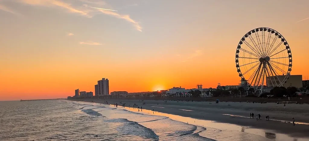
The SkyWheel is 187 feet tall, fully enclosed, climate-controlled, and lit with millions of LED lights after dark, producing the kind of bold color display that photographs well even in less-than-ideal conditions. The 1.2-mile Myrtle Beach Boardwalk stretching alongside it delivers classic coastal boardwalk energy: the ocean on one side, the skyline and amusement architecture on the other. For Instagram purposes, the SkyWheel at blue hour, the 15-minute window between sunset and full dark, creates a glow-against-sky effect that requires no filter and very little skill to capture beautifully.
Best timing: Blue hour (15 min after sunset)
Boardwalk: 1.2 miles, 9th Ave N to 14th Ave N State: SC
The North Carolina Icons
Cape Hatteras Light Station: Buxton, OBX
Tallest brick lighthouse in America · The most recognizable spiral on Earth
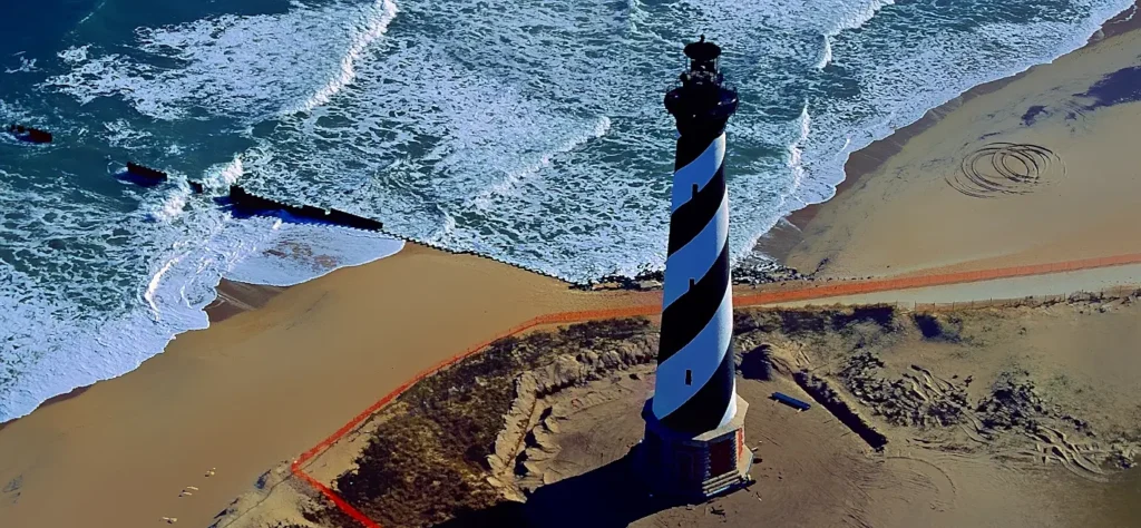
The Cape Hatteras Lighthouse is 198 feet tall, built from black-and-white candy-stripe spiral brick, and has stood at the edge of the most dangerous stretch of coastal water in North America since 1870. The Diamond Shoals off Hatteras Island, where the Labrador Current meets the Gulf Stream, have sunk more than 600 ships. The lighthouse’s job was to warn them away. It couldn’t always. But it has survived everything the Atlantic has thrown at it for over 150 years, which makes it one of the most historically loaded photography subjects on the entire Eastern Seaboard.
Photographically, the composition is nearly perfect. The black-and-white spiral catches every light condition differently. At golden hour, the warm tones of the brick glow against the sky. At sunrise, the shadow stretches hundreds of yards across the dune grass. The National Park Service beach access at the lighthouse provides a clear approach from multiple angles, and the parking lot’s original location, now marked by a small sign, gives photographers a secondary vantage point with the sea oats in the foreground.
Best timing: Sunrise (lighthouse faces east-southeast)
Access: Cape Hatteras National Seashore, free
Climb: 257 steps, open seasonally (fee)
Foreground: Sea oats from original parking lot location State: NC
Local’s Take:
What most photographers miss: the Cape Hatteras Lighthouse was physically moved in 1999, relocated 2,900 feet inland to save it from erosion. The original location is now a small marked site about a half-mile from the current structure, and standing there to look back at the lighthouse gives a dramatically different compositional angle than the main visitor area. Early risers who make the walk get the lighthouse backlit against a glowing eastern sky, with virtually no other tourists in the frame.
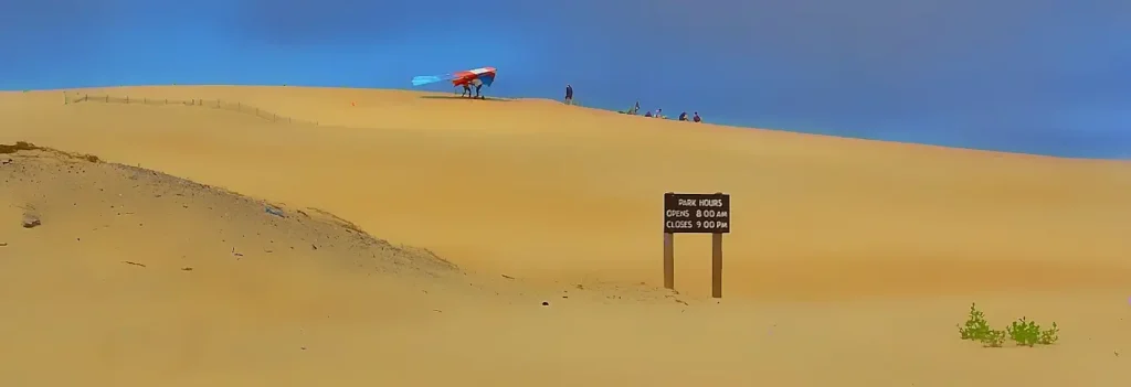
Jockey’s Ridge State Park: Nags Head, OBX
East Coast’s tallest active sand dune · 360-degree Atlantic views
Jockey’s Ridge is a migrating dune system; it moves, slowly but measurably, driven by wind, and its summit shifts seasonally between 80 and 100 feet above sea level. On a clear day at the top, you can see the Atlantic on one side, Roanoke Sound on the other, and a panorama of Nags Head and the OBX barrier island geography that no map can quite prepare you for. The dunes photograph beautifully because dunes are light-responsive: the angle of the sun creates sharply defined shadows in the ridges and ripples, and the color of the sand shifts from pale gold to deep amber as the light drops.
Golden hour at Jockey’s Ridge is well-established among OBX photographers as the single best light condition for dune photography. Hanggliders use the ridge daily in season, which adds a human-scale element to wide landscape shots. Meanwhile, at the base of the dunes, the estuary side of Roanoke Sound creates a second photography scenario entirely, calm water, marsh grasses, and classic OBX sailboat silhouettes at dusk.
Best timing: Golden hour (both sunrise and sunset work)
Access: Jockey’s Ridge State Park, Nags Head, free parking
Bring: Shoes (sand gets very hot in summer) State: NC
Pro Tip:
The north face of Jockey’s Ridge holds its shadow longer in the morning, producing dramatic relief detail in the dune ridges around 8–9 AM. Most visitors arrive midday when the dunes look flat and washed out. The hour after sunrise is when the dunes look like they belong in a National Geographic layout.
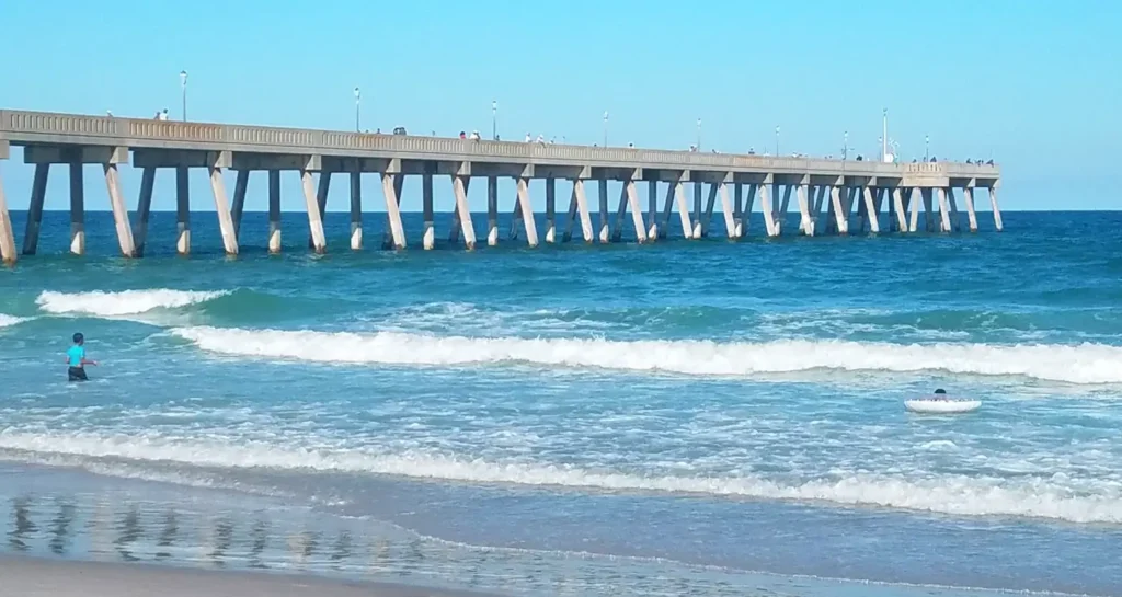
Wrightsville Beach: Wooden Bridges & Crystal Water
NC’s clearest coastal water · Drawbridge views · Banks Channel at sunset
Wrightsville Beach earns its Instagram reputation from a combination of factors that few other NC beaches can match: clear, blue-green Atlantic water (the result of its position south of the Cape Fear River outflow), distinctive wooden access bridges and the Intracoastal Waterway drawbridge, and a west-facing sound side where Banks Channel sunsets deliver colors that read as almost artificially vivid. The Bridge Tender Restaurant on the drawbridge side is itself a photographed subject, the wooden structure reflects in the Intracoastal at golden hour in a way that makes the image look staged.
Kayakers, surfers, and paddleboarders on the water add scale and movement to any wide-angle composition. The Wrightsville Beach beach access walkovers, wooden boardwalks through the dunes, echo the Island of Palms and OBX aesthetic that performs well on Instagram regardless of the specific location.
Best timing: Sunset facing Banks Channel (west)
Signature shot: Drawbridge reflections, Intracoastal Waterway
Access: Free public beach parking (limited in summer) State: NC
📍 Quick Reference: The Full Carolina Instagram Map
| Spot | State | Best for | Best time |
|---|---|---|---|
| Rainbow Row, Charleston | SC | Architecture, pastel color, history | 11 AM–1 PM May–Jul; early AM |
| Boneyard Beach, Edisto Island | SC | Dramatic nature, surreal trees, solitude | Low tide, sunrise |
| Cherry Grove Pier, N. Myrtle Beach | SC | Sunrise pier reflections | 20–40 min post-sunrise |
| The Battery & Waterfront Park, Charleston | SC | Harbor views, Pineapple Fountain, mansions | Golden hour, early morning |
| Murrells Inlet & Brookgreen Gardens | SC | Lowcountry marsh, live oaks, wildlife | Golden hour |
| SkyWheel & Boardwalk, Myrtle Beach | SC | Night lights, LED color, boardwalk energy | Blue hour / night |
| Cape Hatteras Lighthouse, Buxton | NC | Iconic spiral, sea oats, dune grass | Sunrise |
| Jockey’s Ridge, Nags Head | NC | Dune landscapes, aerial views, hanggliders | Golden hour (AM or PM) |
| Wrightsville Beach | NC | Clear water, wooden bridges, sunsets | Sunset (Banks Channel) |
The One Thing Every Shot Has in Common
Look at any great Carolina coast photograph, from a Boneyard Beach sunrise to a Rainbow Row morning portrait to a Cape Hatteras shadow shot, and the common element isn’t the place. It’s the timing. The Carolina coast rewards the early riser and the patient stander-about who waits for the light to do what the light wants to do.
In practical terms: pack your bag the night before, set your alarm for 90 minutes before sunrise, and accept that the best photographs on this coast are taken by people who were already there when the good light arrived. Everyone else is photographing everyone else photographing the thing. That’s a different kind of picture.
Local’s Take:
One thing the tourist photography guides never say: the best coastal photography light on the Carolina coast moves from east to west across the day, which means the SC Lowcountry, with its extensive west-facing marshes and sounds, actually rewards sunset photographers more than sunrise chasers. The NC barrier islands, which run north-south along the coast, catch the best light at both ends of the day. Plan accordingly.
Frequently Asked Questions: Instagram Spots on the Carolina Coast
What is the most photographed spot on the Carolina coast?
Rainbow Row in Charleston, South Carolina is widely cited as the most photographed spot in Charleston and one of the most photographed streets in America. The 13 pastel Georgian row houses at 79–107 East Bay Street attract photographers, portrait sessions, and social media visitors year-round. On the North Carolina side, Cape Hatteras Lighthouse is arguably the most recognizable and widely shared photography subject, appearing in travel media and social posts from around the world.
What is Boneyard Beach at Botany Bay Plantation?
Boneyard Beach is the beach section of Botany Bay Plantation Heritage Preserve on Edisto Island, SC, about 45 miles south of Charleston. Coastal erosion has claimed a former maritime forest, leaving sun-bleached standing and fallen trees along three miles of white sand beach. The result is one of the most visually dramatic and photographed natural landscapes on the Carolina coast. The preserve is managed by the SC Department of Natural Resources, is free and open to the public (except Tuesdays), and is only accessible at low tide.
When is the best time to photograph Rainbow Row in Charleston?
For the most vibrant colors with direct sun illuminating the facades, plan to be there between 11 AM and 1 PM from May through July. For crowd-free photography, arrive before 7 AM, the sidewalk in peak summer can be packed with tourists by mid-morning. Early morning also produces better photographic light than midday, even if the direct illumination angle is less ideal.
What is the best Instagram spot at Jockey’s Ridge State Park?
The summit of Jockey’s Ridge offers 360-degree views, the Atlantic on one side, Roanoke Sound on the other, that photograph best in golden hour light, when the low sun angle creates deep shadow definition in the dune ridges and ripples. The north face of the dune produces the best dramatic shadow detail in the hour after sunrise. The dunes also photograph well at dusk from the sound side, with sailboat silhouettes on Roanoke Sound as a secondary subject.
Is Cherry Grove Pier in North Myrtle Beach free to access?
The surrounding beach is public and free. Accessing the Cherry Grove Pier itself requires a nominal fee (approximately $5) since the pier is part of a campground property. The best photography at Cherry Grove Pier happens from the beach underneath and alongside the structure rather than from the pier deck itself, and this beach access is fully free and available at any hour.
What is the best time of year to photograph the Carolina coast?
Spring (March through May) offers the best overall combination of light quality, moderate temperatures, and manageable crowds. Fall (September through October) is the local photographer’s preferred season, crowds thin dramatically, afternoon temperatures are comfortable, and the lower sun angle creates longer golden hours that produce the warmest light of the year. Summer offers the most dramatic sunrise colors due to humidity and atmospheric haze, but crowds at the most popular spots are at their peak.
Can you climb Cape Hatteras Lighthouse?
Yes, seasonally. The National Park Service opens Cape Hatteras Lighthouse for climbing during the late spring, summer, and early fall seasons. The climb covers 257 steps and reaches the top of the tallest brick lighthouse in America at 198 feet. Timed entry tickets are required and available through Recreation.gov. The lighthouse exterior and surrounding grounds are accessible year-round at no charge as part of Cape Hatteras National Seashore.
Three hundred miles of coastline, two states, and an endless rotation of light that never produces the same photograph twice. Show up before the crowds, face the right direction, and the Carolina coast will do the rest.
For more Carolina vacation area guides and Carolina coastal travel inspiration, keep exploring explorecarolinabeaches.com
Planning a Carolina beach trip? Use our Beach Finder Quiz to get a personalized recommendation, or compare any two beaches side by side with the Carolina Beach Comparison Tool.
📱 Download our free Carolina Beaches app — Get it here